Gettin' Scabby
I signed on as weekend chauffeur recently for the Missus' semi-annual school nurse's conference, this time being held in Wenatchee. The down-side was a somewhat sketchy motel room, possibly a reflection of it being the hunting season as we experienced once before this time of year in this same locale. That time we found ourselves doing a full circuit over the North Cascades and back to Seattle in one day (with infant!) when there was no room at the inn. But I did some lemonade thinking and came up with some options for my down-time in the vicinity. I do enjoy the Wenatchee area, eastern Cascades foothills on the brink of wide-open spaces with lots of astonishing ice-age flood-gouged topography. And the Autumn foliage in Tumwater Canyon is hard to beat, though we had not time to stop and savor, alas.
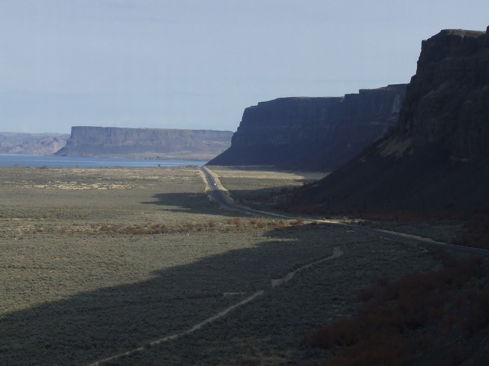
I planned to use Friday afternoon to do some scouting of the lower part of Moses Coulee. This is one
of the major early-stage artifacts of the cataclysmic ice age mega-floods that we have come to learn were instrumental in carving much of the scenery of a good portion of eastern Washington 10,000+ years ago. My first glimmerings of understanding of this astonishing mega-flood concept behind many of the most arresting landforms east of the Cascades came about in some geology-for-the-nongeologist classes when I worked in Richland in the early '70's.
The concept has been pretty fully embraced by actual thinking folks by now (dogmatic Christian fundamentalists might struggle with this). J (no period!) Harlan Bretz, an iconoclastic geologist, was the primary progenitor of this ice-age flood concept way back in the 1920s. As you can imagine, his theories did not go down well with his peers, fully absorbed in the widely-believed principle at that time that geological processes of necessity always involve very gradual change. Bretz richly deserves the Penrose medal he won in 1979, the highest award for a geologist, for his successful development and defense of an astonishing out-of-the-geological-sciences-dogma box. This was science at its best.
It's been a remarkable experience personally to gain an understanding of this mega-flood concept and its reflection in the landscape. I have spent most of my life in the Pacific NW, and have traversed the eastern part of the state a myriad of times, large colonnades of basaltic columns forming steep canyon sides a signal for me from probably pre-school age of the euphorically different nature of the wild out-of-doors on the dry side of the mountains. It has been a major revelation to learn that a series of astonishing mega-floods were the primary cause of many of these fantastic landforms. That huge rock in the picture above is very likely a chunk of the thick layers of basalt that forms much of the Columbia Basin, likely dug out by the latest ice-age glaciers and ice-rafted to this site.

A couple years ago, wheeling across Highway 2 east of Wenatchee and headed for Spokane, I went giddy when I realized that we had just descended across an astonishing mega-flood gravel bar I had read of and were crossing the Moses Coulee that was a big component of this theory. I'm sure I had been through here before, especially prior to the completion of I-90, which these days carries most through-traffic further south.
I missed the turnoff for Moses Coulee on the first pass. A few miles later, by now certain I'd missed it, I went ahead and took a brief tour of the Crescent Bar area on the Columbia, yet another artifact (flood bar) of those floods. Great location for water-sports enthusiasts.
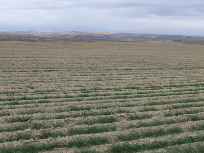
Regrouping, I was relieved to find that coming from the other direction there was a pretty clear sign that matched what I had read (though I guess not the bold cajoling MOSES COULEE that might have synched with my personal agenda). There is a surprising amount of agriculture I learned in the lower coulee. Quite scenic if you like dry and sere. That's good with me, but I am easy when it comes to scenery. I cherish my Puget Sound green-mania despite the fact that the trees often obscure the views, but I also love the great wide open. No reason I should have to settle!
Short of time at this point I agonized that I could not stop for photos. I need to go back some day for at least some images of the fascinating ranch that marks the end of the lower coulee. There is the equivalent of a used-car lot of broken-down trucks and land-working machines parked along the road. A major eyeful. Other photogenic elements include an amazingly flat stretch apparently due to a backwater lake caused by ice-age blockage of the lower coulee.
I thought there was a good chance I'd be back this way again. Had I ended up retracing my route I would certainly have attempted some photos. But at this point back to Wenatchee, enthusiastic that the pavement had ended but wary of what that might foretell. My clock was ticking given deadline to pick up my favorite nurse, but just about the time I had concluded I might need to reverse course a tiny sign encouraged me to proceed, leading shortly to a junction with Hwy 2 right in the middle of that same monstrous gravel bar.
In short, nurse and chauffeur reunited in the city of apples. We split a great prime rib special at justifiably popular downtown restaurant, McGlinn's. Motel was not as sketchy inside as it was out, though the furnishings are a couple decades out of date. We were also short of lumens.
Satyr's Day was much more open to my designs. We greatly enjoyed our breakfast together, surprised to be the first in the door at McGlinn's again.
I dropped Marg off at the same old place (Red Lion) and headed back up Highway 2. My primary target was Steamboat Rock in the upper reaches of Grand Coulee, though I had several other targets in case time allowed or eventualities dictated a change in plans. We'd driven by SR at least a couple times recently, but I'd never been in a position to actually do the hike. For that matter, I didn't really have a grasp at what the hike involved. I was pretty sure it would be a major sales job to persuade Marg this would be fun to do together, especially in summer and in the midst of a trip with further more-important destinations.
I made note of the intersection where I had turned onto 2 on Friday, totally unnoticed on our last transit of Hwy 2. I think I saw a sign at least acknowledging "Moses Coulee," but so small you had to stop to read it, and thus almost apologetic. The local tourist bureau is not boosting this. Solitude!
 I pressed on with Steamboat Rock in mind. I made a brief stop when I unexpectedly saw what I took for erratics in otherwise well-graded fields. I suspect these are not true glacial erratics, i.e., rocks of foreign origin carried in by glacier, since they appeared to be the native basalt stuff. But out of place anyway, namely astonishingly huge chunks of basalt likely quarried somewhere like, say, Grand Coulee and thrown up here. But note the scale - I think there are a couple buildings and electrical towers to the right.
 It was nice to have a good deal of this route finally feel somewhat familiar. After all, I've savored this particular bit of road three times now in only the last five or so years. Wish it had been more. This country sings to me.
My reading had alerted me to the term "million-dollar highway" for a stretch likely blasted
 through the basalt in anticipation of the filling of Banks Lake as part of the major BLM irrigation scheme implemented for much of the Columbia Basin. I'd driven it before, but never before paid attention to the slots through the basalt upstream of the lake water level with elevated awareness.
I parked at a large campground just east of Steamboat Rock. There were a few folks nosing about one of the trail accesses, but otherwise I felt, as I so often do, out of step with the people around me. Almost all of them were equipped with a large RV, boating, or otherwise occupied.
 The hike involves a moderately steep climb up the east side of the Rock. From there your choices include a short circuit of the south portion of the rock or a longer circuit of the north portion of Steamboat. Of course you can do both. I went for the north circuit, admittedly cutting corners a bit, frankly as I was attuned to the UW's football game. I hoped to catch a bit of the game on the radio, much as I would have preferred to watch it.
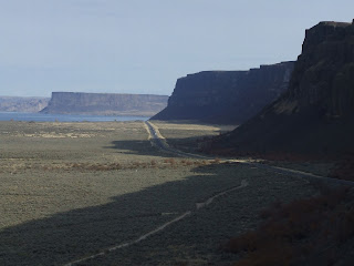
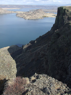 This is a great walk, though not for the undisciplined adolescent (or their parents!) or vertigo-sufferers, since a good part of the at-times very faint trail runs within 20 feet of a precipice something like 800 feet above the talus slopes below. Scary. A discerning examination of the view to the north (left image above) reveals the mega-flood-eroded gap that led to the creation of this astoundingly Grand gouge in the earth.
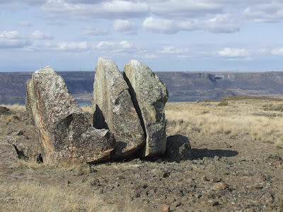
There are several huge granite erratics atop this amazing basaltic rock, including the split you see here. A fabulous hike, in my case made exceptional by having it all to myself. I do work at loving my fellow-folks, but in the great out-there, where there is the potential to connect, I find I must be pretty selective as to companions. "None" is only slightly behind my one-hand-count compadres.
 I need to let off a little steam over the recent political insanity, Dylan's Idiot Wind lyric (Blood on the Tracks) "from the Grand Coulee Dam to the Capitol" my flimsy thematic connection. It seems undeniable that while much of Congress these days is truly certifiable, they are provided just enough cover by plain folks who have been the beneficiaries as have we all, sadly the well-off disproportionately too much, of federal government largesse. I find it truly pathetic that those who have been uplifted by government intervention though they either are too stupid to recognize it or too dishonest to admit it, have been so embarrassingly played by the right-wing ideologues, to the benefit of those so wealthy they dare fantasize about a life unfettered by regulation now that they are disgustingly flush.

I planned to use Friday afternoon to do some scouting of the lower part of Moses Coulee. This is one
of the major early-stage artifacts of the cataclysmic ice age mega-floods that we have come to learn were instrumental in carving much of the scenery of a good portion of eastern Washington 10,000+ years ago. My first glimmerings of understanding of this astonishing mega-flood concept behind many of the most arresting landforms east of the Cascades came about in some geology-for-the-nongeologist classes when I worked in Richland in the early '70's.
The concept has been pretty fully embraced by actual thinking folks by now (dogmatic Christian fundamentalists might struggle with this). J (no period!) Harlan Bretz, an iconoclastic geologist, was the primary progenitor of this ice-age flood concept way back in the 1920s. As you can imagine, his theories did not go down well with his peers, fully absorbed in the widely-believed principle at that time that geological processes of necessity always involve very gradual change. Bretz richly deserves the Penrose medal he won in 1979, the highest award for a geologist, for his successful development and defense of an astonishing out-of-the-geological-sciences-dogma box. This was science at its best.
It's been a remarkable experience personally to gain an understanding of this mega-flood concept and its reflection in the landscape. I have spent most of my life in the Pacific NW, and have traversed the eastern part of the state a myriad of times, large colonnades of basaltic columns forming steep canyon sides a signal for me from probably pre-school age of the euphorically different nature of the wild out-of-doors on the dry side of the mountains. It has been a major revelation to learn that a series of astonishing mega-floods were the primary cause of many of these fantastic landforms. That huge rock in the picture above is very likely a chunk of the thick layers of basalt that forms much of the Columbia Basin, likely dug out by the latest ice-age glaciers and ice-rafted to this site.

A couple years ago, wheeling across Highway 2 east of Wenatchee and headed for Spokane, I went giddy when I realized that we had just descended across an astonishing mega-flood gravel bar I had read of and were crossing the Moses Coulee that was a big component of this theory. I'm sure I had been through here before, especially prior to the completion of I-90, which these days carries most through-traffic further south.
I missed the turnoff for Moses Coulee on the first pass. A few miles later, by now certain I'd missed it, I went ahead and took a brief tour of the Crescent Bar area on the Columbia, yet another artifact (flood bar) of those floods. Great location for water-sports enthusiasts.
Regrouping, I was relieved to find that coming from the other direction there was a pretty clear sign that matched what I had read (though I guess not the bold cajoling MOSES COULEE that might have synched with my personal agenda). There is a surprising amount of agriculture I learned in the lower coulee. Quite scenic if you like dry and sere. That's good with me, but I am easy when it comes to scenery. I cherish my Puget Sound green-mania despite the fact that the trees often obscure the views, but I also love the great wide open. No reason I should have to settle!
Short of time at this point I agonized that I could not stop for photos. I need to go back some day for at least some images of the fascinating ranch that marks the end of the lower coulee. There is the equivalent of a used-car lot of broken-down trucks and land-working machines parked along the road. A major eyeful. Other photogenic elements include an amazingly flat stretch apparently due to a backwater lake caused by ice-age blockage of the lower coulee.
I thought there was a good chance I'd be back this way again. Had I ended up retracing my route I would certainly have attempted some photos. But at this point back to Wenatchee, enthusiastic that the pavement had ended but wary of what that might foretell. My clock was ticking given deadline to pick up my favorite nurse, but just about the time I had concluded I might need to reverse course a tiny sign encouraged me to proceed, leading shortly to a junction with Hwy 2 right in the middle of that same monstrous gravel bar.
In short, nurse and chauffeur reunited in the city of apples. We split a great prime rib special at justifiably popular downtown restaurant, McGlinn's. Motel was not as sketchy inside as it was out, though the furnishings are a couple decades out of date. We were also short of lumens.
Satyr's Day was much more open to my designs. We greatly enjoyed our breakfast together, surprised to be the first in the door at McGlinn's again.
I dropped Marg off at the same old place (Red Lion) and headed back up Highway 2. My primary target was Steamboat Rock in the upper reaches of Grand Coulee, though I had several other targets in case time allowed or eventualities dictated a change in plans. We'd driven by SR at least a couple times recently, but I'd never been in a position to actually do the hike. For that matter, I didn't really have a grasp at what the hike involved. I was pretty sure it would be a major sales job to persuade Marg this would be fun to do together, especially in summer and in the midst of a trip with further more-important destinations.
I made note of the intersection where I had turned onto 2 on Friday, totally unnoticed on our last transit of Hwy 2. I think I saw a sign at least acknowledging "Moses Coulee," but so small you had to stop to read it, and thus almost apologetic. The local tourist bureau is not boosting this. Solitude!

 It was nice to have a good deal of this route finally feel somewhat familiar. After all, I've savored this particular bit of road three times now in only the last five or so years. Wish it had been more. This country sings to me.
My reading had alerted me to the term "million-dollar highway" for a stretch likely blasted
 through the basalt in anticipation of the filling of Banks Lake as part of the major BLM irrigation scheme implemented for much of the Columbia Basin. I'd driven it before, but never before paid attention to the slots through the basalt upstream of the lake water level with elevated awareness.
I parked at a large campground just east of Steamboat Rock. There were a few folks nosing about one of the trail accesses, but otherwise I felt, as I so often do, out of step with the people around me. Almost all of them were equipped with a large RV, boating, or otherwise occupied.

 This is a great walk, though not for the undisciplined adolescent (or their parents!) or vertigo-sufferers, since a good part of the at-times very faint trail runs within 20 feet of a precipice something like 800 feet above the talus slopes below. Scary. A discerning examination of the view to the north (left image above) reveals the mega-flood-eroded gap that led to the creation of this astoundingly Grand gouge in the earth.
 There are several huge granite erratics atop this amazing basaltic rock, including the split you see here. A fabulous hike, in my case made exceptional by having it all to myself. I do work at loving my fellow-folks, but in the great out-there, where there is the potential to connect, I find I must be pretty selective as to companions. "None" is only slightly behind my one-hand-count compadres.
 I need to let off a little steam over the recent political insanity, Dylan's Idiot Wind lyric (Blood on the Tracks) "from the Grand Coulee Dam to the Capitol" my flimsy thematic connection. It seems undeniable that while much of Congress these days is truly certifiable, they are provided just enough cover by plain folks who have been the beneficiaries as have we all, sadly the well-off disproportionately too much, of federal government largesse. I find it truly pathetic that those who have been uplifted by government intervention though they either are too stupid to recognize it or too dishonest to admit it, have been so embarrassingly played by the right-wing ideologues, to the benefit of those so wealthy they dare fantasize about a life unfettered by regulation now that they are disgustingly flush.
posted by Sir Gumbo at 11:13 PM
![]()
![]()

0 Comments:
Post a Comment
<< Home